
|
|

Project Overview
If you have ever smelt smoke, seen a fire truck, heard a siren, felt the wind change and wondered what’s going on, then this app is for you. Real-time information on emergencies including Fires, Floods, Storms, Rescues, Hazmat, Cyclones, Tsunamis and Earthquakes is delivered in real-time across Australia to you keep informed.
With informed decision making the key to successful outcomes in all facets of emergency management and public safety, it is paramount that cohesive information is made available to both the public and emergency managers during emergencies. EmergencyAUS provides this in real-time across Australia
Organisation
Team
EmergencyAUS was developed under partnership between RIPE Intelligence and GRIDSTONE.
RIPE Intelligence
Luke Corbett - Subject Matter Expert
Tarron Newman - Lead back-end developer
GRIDSTONE
Lembit Pikkat - Project Manager
Jonathan Grant - Technical Director
Jason Chieng - Creative Director
Chris Horner - Android Developer
Valery Shorinov - iOS Developer
Project Brief
This app could save your life... really!
Your safety is your responsibility, but if you are not aware of what is happening around you, it is hard to keep you and your family safe. The EmergencyAUS app brings together official emergency information from hundreds of sources, empowering its users to make better informed decisions during emergencies.
To support official emergency warnings and information, EmergencyAUS enables users to provide observations of the event. From the early indications of an emergency (I feel a storm brewing) to a full blown disaster (I see a bushfire at my location), users can share vital information to help others stay informed.
Sensory Observations are structured to mimic habits of social media users and are categorised by sense (I see, I feel, I hear, I smell). This simple categorisation makes it easy for users to interact with the system and enables accurate filtering and searching unlike Facebook and Twitter. Observations can also include geo-referenced photos.
EmergencyAUS enables users to set a watch area, a zone covering a selected radius from an identified point, and receive alerts directly to their phone 24/7 for all warnings and incidents in their area of interest.
Whether you’re at home or on holidays, EmergencyAUS will help keep you safe. It is the app everyone needs, but hope they never have to use.
Project Need
The provision, consumption and sharing of information during emergencies is paramount to making safe decisions. The consequences of an incorrect decision can have catastrophic outcomes; the decision to stay or go, turn around or keep going, are the decisions that can kill if made without all the information. If the public was able to make the correct and safest decision during (and prior to) emergencies, the impact of emergency events would be significantly diminished. The authorities do their best to coordinate and publish official information however this will always be behind the fact; it’s just a matter of how far.
In many cases individuals being impacted by an emergency are better informed as to what is happening directly around them. The challenge is to bring these small pieces of information together, into a real-time dynamic picture integrated with official information that is easy to use and understand. EmergencyAUS delivers information from the Emergency Information Network which covers all jurisdictions and multi hazards across Australia.
Through the use of EmergencyAUS, users impacted by emergency situations have the opportunity to make better informed decisions, faster, leading to community resilience and self-reliance. The app leverages available mobile technologies and services to enhance the user’s ability to find relevant information. Features like spatial sorting (distance from user) of information, geo-referenced photos and push notifications for events in the area.
User Experience
EmergencyAUS is available on both iOS and Android platforms, and therefore accessible to most smartphone and tablet users.
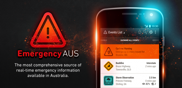
The app provides users with emergency information from hundreds of sources across Australia via a coordinated interface. This information (more than 6 gig per day) is automatically gathered from hundreds of websites, processed to improve spatial information, standardised to the national parity for emergency terminology, modified to fit within the national framework for multi hazard warnings, and provided to users in an easy to use and beautifully designed app.
This provides consistency in the information provided nationwide, ensuring information is easily interpreted.
The app displays information via a map and list interface. This enables users to find relevant information from their current location, area of interest or from sorting filtered lists. Users can also set up watch areas via a map interface to receive automatic notifications of emergency incidents or warnings in this area. Once informed, users can choose to provide information about an event they are witnessing by using the interactive function. This guides them through a process of adding an observation to help keep others informed.
EmergencyAUS was released in October 2012 and now has over 92,000 users, monitoring over 22,000 watch zones. During this time it has sent 4.3 million push notifications and users have submitted over 10,000 observations.
Project Marketing
We have been very successful in gathering a very strong following in social media considering the duration of our presence. We utilise social media to post information on current emergency events and important safety information and warnings. This is conducted primarily on Facebook, where we are currently tracking with more than 23,000 followers, in under 12 months, which is more than many State based emergency services.
We also post 3D Google earth videos on YouTube of real-time fire perimeters as well as Tweet out relevant warnings and information. We have made a number of emotive videos along with a short over view video. These videos give users and potential users something a little different to share with their friends to spread awareness of the app.
With around 3% of the advertising budget of a single Government funded app in our class, we have managed to keep pace with the big boys though engaging, entertaining, active and informative use of social media.
Our marketing has been aided by the recognition we have received from a number of technology awards in Australia for EmergencyAUS.
August 2013- National iAward, Community Category (received Victoria state award in June 2013)
March 2013- Judges award at the GeoNext StartUp Showcase
December 2012- AWS Cloud Warrior Award - Amazon Web Services (AWS) Technical Innovator Awards
December 2012- Gold MoMo Award at the 2012 Mobile Monday Melbourne - Mobile Industry Awards
Best New Service or Application
This category recognises the best new service or application on a mobile platform.
More Details